As
I have mentioned before, yesterday was "Audax day" for me.
A three-day weekend off work meant it was the ideal time.
Rest all day Saturday, ride all day Sunday, and recover all day Monday (today).
I took a bunch of pictures, so I'll tell this one as a photo-story.
 |
First I had to choose a route and get it approved by Audax UK, the appropriate Audax/Randonneuring club in the UK.
Route had to be 200km using the minimum walkable distances between the "checkpoints". Walkable distances are chosen so that short-cutting down an alley won't help - the 200km "shortest route" has already taken that in account! My route came out as 208km, on the "shortest distance" method. "Proof" of arriving at "checkpoints" can be something as simple as an ATM receipt or a coffee shop receipt. Time, date and location are needed. Be aware that a lot less places are open on a Sunday than on a Saturday! |
 |
My "actual" route, as recorded with my Garmin 310xt watch, and uploaded to Strava. When I knock off the 2km to my house and back at the start and end, instead of doing 208km, I actually did 228km.
Still only counts as 208km though!
It is the "minimum" distance that counts, not the "actual" distance.
Mind you, it avoids arguing about GPS accuracy - some smartphones (I'm looking at you, Apple!) have built a reputation for being great 'phones with rubbish GPS chips/software algorithms!
The big route differences between the "planned" and "actual" routes are that I went the "cycle friendly" way via Headington and Worminghall on the way back from Oxford, I took the main road from Great Missenden to Amersham (longer. but quicker), I took the Ebury Way off-road route from Rickmansworth to St Albans (pretty, but dog-slow, AND longer!), I took the Alban Way to Haltfield, then the cycle path top Welwyn Garden City (again, nicer than the main road, but slower AND longer!), then I took the Luton to Dunstable Busway rather than the A505 (more about that later!), turned the wrong way at the end of it, and had to go back, then after that it was pretty much the same. |
 |
Heart-rate analysis for the ride. For longer rides, you gotta keep the pace down (except hills).
I was running late towards the end, so I went a bit faster, helped by going downhill and a tailwind taht had picked up a bit! |
 |
Mermaid on Satuday afternoon. weighed in at 18,0kg, as is. then there are the panniers and basket (for my food, water, tools and spares), which weighed in at more than 13kg, so over 31kg, "ready to roll".
Just how cheap is Mermaid? well, to be honest, although Mermaid started life as a cheap, heavy, steel bike, there have been a few changes. To actually build up a bike like Mermaid would cost around 300 to 350 pounds (about $500, 420 euros), which given Mermaid's original purchase price of 120 quid (about $190, 165 euros) is something of an increase. Be aware that a lot of the new parts were bought on "clearance", too, which kept the cost down. The weight still reflects the original cheap steel frame, forks and mudguards. Yep, Mermaid has STEEL mudguards/fenders.
Current spec is:
Marathon Plus tyres, 700x35
36 spoke wheels with Mach1 heavy-duty double-walled rims
Shimano Deore V-brakes.
Steel "North Road"-style handlebar, with SRAM 3x8 twist shifters and cork grips.
Spa Cycles triple 175mm chainset, current sporting 48/34/26 rings (the smaller two are steel!)
SRAM 11-32 8-speed cassette
Shimano Alivio rear mech, with a cheapy Shimano triple front mech)
And a new SRAM 8-speed chain for this season! |
 |
| Organic buckwheat noodles at 5 am to set me up for the day. |
 |
A couple of mugs of tea, too.
Actually, I had 4 mugs.
Double century has to be worth double tea! |
 |
three "large" eggs, too.
then a can of "rice pudding"
(yes, it was "Ambrosia") |
 |
The first checkpoint - Aylesbury Market Square. Just got to check my bank balance at the ATM (and keep the receipt!) and I'm good to go.
Only thing is, I'm running a bit late.
Plan had me arriving at the Market Square at 06:00, and departing at 06:05.
My ATM receipt is stamped at 06:16, so that is at least 11 minutes "down the pan" already! |
 |
Dawn, having recently "dawned"
gives a lovely colour to the top of
the bridge support on the "Bourg Walk"
- the centrepiece of our town's cycling
infrastructure. |
 |
| And out through Haddenham. This is Fort End. |
 |
...before rejoining the main road for the
section to ... |
 |
| Thame, with the church in the morning sun. |
 |
Not getting lost this time -
I "practiced" Thame 2 weeks ago! |
 |
| Oldie-worldy in Thame. This place pre-dates Shakespeare! |
 |
| ohh- a nice bit of infrastructure! |
 |
| one to remember for the way back - the turning for the Phoenix Trail |
 |
| then, after thame, a nice, little-used MUP (shared path) |
 |
But it's back on the main road for the Tiddington
section. Not many drivers about early on a Sunday! |
 |
| Then off the main road into Wheatley |
 |
Cycle infrastructure signs!
Route 57, with or without the hill, |
 |
I choose "the hill":-)
It is about a 90m climb (c. 300ft). OK when you are fit! |
 |
At the top, as we enter Shotover woods and park,
some lazy oaf has dumped a load of rubbish.
Fly-tipping is endemic in some parts of Britain,
sadly :-( |
 |
Meanwhile I've found a discreet tree to lean the
bike on. Time for a "comfort" break. I was very
well hydrated at the start (remember the 4 mugs of tea!)
and it's gotta come out sometime. |
 |
At the top of the hill, it is more a wide track than a road.
Bit lumpy in parts, so don't bring a "road" bike with fancy wheels up here! The rubber belt in Mermaid's tyres helps to soak up some of the bumps, and remember, I have
heavy-duty wheels, too! |
 |
After a good hill, there is a good descent :-)
This is one of the easier bits of getting to Oxford! |
 |
The light is still red by the way.
This loser stopped at the front of the cycle box, then as he became ever more impatient, crept forwards into the junctions.
The cycle box is for me, because I am on a bike, not you with your heap of junk! |
 |
a painted cycle lane and a 20 mph (32 km/h) speed limit.
Life is sweet in Oxford! |
 |
Loads of little groups of bikes
all over the place in Oxford! |
 |
| Coming into the centre |
 |
| "Dreaming Spires", anyone? |
 |
Carfax Tower, Oxford,
12th century, and at the end of Cornmarket
where there are lots of banks etc, for a "proof"
receipt! |
 |
| 2 hrs 6 mins from my house to Oxford. |
 |
As well as banks, there is a Starbucks open by 8:15 on a Sunday
morning. There is a "Golden Arches", also open, opposite.
For the "proof" receipt, I got a time of 08:12, against a scheduled time of 08:15 to 08:20. So I have made up for the late start, and I'm a few minutes up! |
 |
Approaching the hill up to Headington on the way out of Oxford. Oddly, the hill has a 30 mph limit (48 km/h), while the section before and after are 20 limts! (32 km/h)!
As I approached the lady jogging (on the left of the picture), I noticed she had VERY well-defined calf muscles. Looks like "runner's" legs, I thought. Not "extreme" legs like Chris Froome's, with veins standing all over them (the 50-year-old, 3hr marathon, guy I work with has legs like that, too!). Just "runner's" legs.
I passed her, but she actually caught me up on the hill! She didn't slow down - just kept jogging. She was jogging that hill at the speed I was cycling it! The legs don't lie.
I've commented before on folks that buy all the fancy kit, but forget to work on the most important parts of cycling and running - the heart, lungs, energy systems, and the legs!
You can't buy your way out of putting the miles in! |
 |
| Top of the hill and back into the lower speed limit. If only all streets where like this :-) |
 |
| In Oxford, there are lots of "old" things. This is "Ye Olde Golden Arches" at the junction of the Eastern ringroad and the A40. |
 |
| A nice cyclepath to take me along nect to the A40 |
 |
| Once we are out of Oxford, the path gets a LOT narrower |
 |
This pic was just to remind me that
my butt still felt fine by this point! |
 |
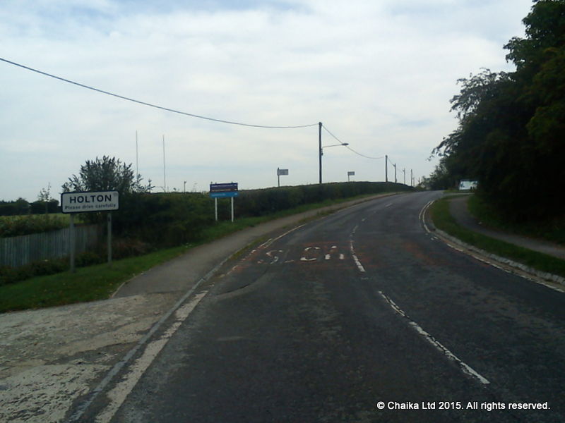
Instaed of going back to thame on the "main" road, I'm going through
Holten, and will shortly join Cycle Route 57 again. |
 |
| Just cruising along. It;s going to be a long day, and I don't want to use all my strength too early! |
 |
A bit of cloud cover
- but it looks like it will rain later.
Forecast is for about 4pm. |
 |
| I actually stopped and went back to take a picture of this sign, |
 |
| Using the minor road to Worminghall to cross the M40 (the main London to Birmingham road - Britain's 1st and 2nd largest cities!) |
 |
| picked up the pace a bit. |
 |
Back to Thame, and onto the Phoenix Trail.
Remember the sign in the earlier picture I passed on the "way out"? |
 |
Most of it is a good width, and the busier parts
are paved. You can see it is a
"rails to trails"-type route.
About 10 miles (16km) of this for me.
This is the life! |
 |
| Checking the map near Askett. I wanna be on the red line! |
 |
More "olde worlde" in Askett,
"Real" old houses always look like they have been built by a drunk :-) |
 |
| Cadsden hill. A Category 4. It goes up ... |
 |
| ... turns, and goes up a bit steeper |
 |
| Ohh, look! Its levelling out ... |
 |
| ... but there's more of it yet |
 |
before finally reaching the summit in the woods.
OK, if you are fit, even with a bike (and kit) weighing about 30kg (66lbs) at this point. |
 |
Then a faster, downhill, section to Great Missenden.
this is where Roald Dahl used to live, the Norwegian fighter pilot turned children's author (Charlie and the Chocolate Factory, etc. etc.). |
 |
| A quick section on the main road to Amersham with the cars whizzing past. |
 |
Amersham has a Tesco open 10-4 (I think)
on a Sunday. Toilets and a "proof" receipt
available! But not for me on this trip,
I have Oxford to Rickmansworth as a
single 62km stretch. |
 |
| Rickmansworth finally appears on the signs. |
 |
I stopped on the way out of Amersham to move more food and water from the panniers to the front basket, and rotate the "empties" into the panniers. As you can see, I am riding in "tour" mode, not "lightweight" mode!
The bike weighs 18kg and the panniers weigh 13-and-a-bit, although they are probably a good bit under 12 by now because I have already eaten some of the food and drunk some of the water! |
 |
I grew a beard this month. Only problem is that it shows my age up, rather. Look at the white bits!
Lucky to still have all my hair! The beard's gotta go! |
 |
Rickmansworth, for the third "proof" receipt.
Scheduled time was 12:11 to 12:16.
It's just coming up to 12.
I'm in front!
(the receipt say 11:57) |
 |
Seeing as I am about 15 to 20 minutes up,
and I have a 30 minute "buffer" at the end
of my schedule, I might as well go on the
"pleasant" way, rather than the faster
"main road" route. |
 |
| Ebury Way - some paved surface, mostly grit. |
 |
| Ebury Way gives me some pleasant views. |
 |
That packet of fig biscuits seems to have been eaten :-)
With the front basket, I can "snack and ride" to my heart's content! |
 |
Off-road route, AND signage.
I could get used to this! |
 |
It's just started to rain - just a few spots.
I guess it is about 12:30. |
 |
OK, so the signage petered out, and I lost it crossing Watford,
but found it again. Lost some time. Now it is raining properly,
and I'm hiding under a bridge while I get my waterproofs on. |
 |
well that explains some of the weight in the panniers!
a rain jacket AND trousers.
Forgot the overshoes, but it is Summer, so while my feet will get wet, they won't get THAT cold anyway! |
 |
Out of Watford on Ebury Way, and under the M1 motorway.
Time for another discreet "comfort break" |
 |
| My basket has a "drawcord" raincover built into it, which keeps the worst out! It also helps to keep the stuff in the basket on very rough road sections! |
 |
Ebury Way leads into wet tarmac (asphalt) on a minor road leading
to St Albans. |
 |
Rain everywhere. My jacket is fairly light,
but only really "showerproof"! |
 |
After a bit more looking at a rapidly decomposing map, I find Alban Way, that runs from St Albans to Hatfield.
And it is still raining. |
 |
Hatfield Galleria - a large mall to try and cover up the declining fortunes of a town that was.
This is where the world's first production commercial jet airliner was built (the DH Comet).
Yet another British invention that everyone assumes was invented by the Americans.
Now the aircraft factory and aerodrome are long closed,
and the space has a set of boxy warehouses and the like in it.
Anyway, a bit more trouble with the routing, and I finally got my receipt from Welwyn Garden City at `14:47.
So, on the Rickmansworth to Welwyn Garden City section, I threw away my "lead", and I am now 30 minutes behind schedule.
All the extra distance of the off-road route,
as well as the slower pace and the unclear signage meant I took a LOT longer than I expected!
Good job I have that 30 minute buffer at the end.
This could be close ...
At least the rain has stopped! |
 |
More trouble getting out of Welwyn garden City. the cyckle route signs seem to be taking me in circles!
After a false start, which I realised was wrong, I founf, almost by chance the right route, an almost traffic-free route through Ayots Green. Bit to twisty and up and downy to make good time though.
A bit of luck came my way, I made a few good guesses about the route, and I founf myself on the road to Luton.
So I followed it.
Then through Luton on the flyover main-road, Sometimes cyclists aren't allowed on flyovers, but I didn't see any signage.
Out of Luton, and I see the much-written about Luton to Dunstable Busway.
This is a "showpiece" bit of infrastructure for cyclists and public transport, apparently,
Busses and bicycles can avoid all those nasty buy roads, and just go from A to B.
Well, that's the theory, anyway! |
 |
| Before long the nice tarmac (asphalt) has gone, and it is grit for us cyclists! |
 |
This I did not expect!
A path restrictor, and even Mermaid's handlebars are too wide!
A nice pair of "compact" drops would, no doubt, fit nicely.
But what about the rest of us?
After a bit of cursing, and thinking, I found it is JUST ABOUT possible to wiggle the bike through if you lean it quite a bit to one side, and lift it a bit sideways at the right point.
Wonder how much time I lost just going through these "gates" |
Some of those Busway gates weren't well though out, either. I dodged one by walking about 6 feet up the busway and bumping the bike onto the path (no fence at that point), another one had a pieve missing from the fence by the gate, so I just walked through, a third had a muddy track on the verge that folks had made dodging the gate (no fence on that side!).
And that was how I had my spectacular "Rule #49" crash.
I was at yet another of those Busway gates, and there was a track on the bank next to the gate that went up and round and down.
I'll give it a go, thought I.
Except I didn't make a good gear choice and comically toppled over at the highest point, falling back down the bank to the path.
Mermaid, no doubt imparted a nice bit of rotational momentum by my falling off (and down) sideways, and no doubt carried by the weight of the panniers, did a 270 degree sideways twist and landed on the right-hand pannier (I fell off to the left!). So what should have been the top pannier became to bottom one!
I had to take rapid evasive action, too, to avaoid Mermid belting me on the way down too!
You don't want to get hit by a bike (and kit) weighing in at still more than 25kg at this point!
(the weight was down from the start, as I had consumed quite a bit of my supplies, and I was still wearing the waterproofs rather than carrying them!
The pannier that hit the ground seems to have taken some of the shock by detaching itself, and the basket was knocked a bit out of true as well. It all looked serviceable, so I put the stuff that had fallen out of the basket back in, and continued on.
At the time I felt like I had a bruised rib and a slight groing strain, but seeing as they seem to have disappeared by today (the day after) I'm guessing those were due to the distance I had ridden rather than the fall itself.
Anyway, back to the Busway.
I rode the path right to the end,a nd then I wasn't sure where I was. So I cycled towards some buildings, to find the Luton to Dunstable Busway turns out nearer to Houghton Regis than it does to Dunstable.
More time wasted, and another couple of "empty" kilometres clocked up.
Back towards Dunstable, and I picked up the A5, then the A505.
I knew these bits from when I used to drive lorries.
Straight into Leighton Buzzard with no issues (i'd already scouted where the banks were in advance!).
But I was WAY behind schedule.
The Busway, plus the crash, plus the false turning to Houghton Regis meant I got my Leighton Buzzard receipt at 17:32.
The schedule was supposed to be 16:42 to 16:47,
So I am now at least 45 minutes behind with only a 30 minute "safety buffer" in the schedule.
I have 15 minutes to make up in the last 41km.
At least I "knew" the last bit, as I had previously "scouted" the route, and identified where the ATM in the next town was (the last ATM was to be the Mrket Square in Aylesbury, where I started),
But the real question was whether I could make up that 15 minutes ....!
Desparate measures for desperate times.
Time to hit the "emergency" Red Bull.
(it's store "own brand" imitation Red Bull!).
And a good slug fo water to make sure I am not dehydrated,
I have another 90m (300ft) climb in the woods to go.
I'm going to have to shift some ...
Rule #
49
//
Keep the rubber side down.
More on Velominati.com: http://bit.ly/xO3YIb
Rule #
49
//
Keep the rubber side down.
More on Velominati.com: http://bit.ly/xO3YIb
 |
Berkhamsted, After the hard. long, climb, there was a nice long descent into Northchurch, then turn left into Berkhamsted.
So many traffic signals!
This one is the most annoying - it is a 3-way set of temporary lights (for roadworks) that lets the three streams off traffic go separately - involving quite a delay for the other two streams!
But I took this picture while waiting on the "way out", rather than the "way in", so the wait didn't seem so bad.
I got my Berkamsted receipt at 18:52 (schedule was 18:09 to 18:14), so, allowing for the 30 minute "buffer" I had cut my deficit from 15 minutes to 8 minutes.
19km to go!
The wind had picked up to about a 15 mph (24 kp/h) cross-headwind on the first part of the previous leg - then I turned into the woods for the hill and it didn't matter.
For the final leg, that wind is pretty much right behind me!
Berkhamsted is up on the hills, and Aylesbury is on the plain below them, so, although there is some more modest climbing to go, overall the last section is DOWNHILL. Indeed, there is about a 4 mile downhill section through Aston Clinton! |
 |
Stopped in Aston Clinton.
More roadworks,
I flew down the hill - the weight of the bike and the tailwind shifting me at a decent speed.
Can't have been much off 30 mph (50 km/h) - maybe a touch more.
And the weight and wind just kept pushing me on the more gentle slope in the lower parts of Aston Clinton.
Lost a minute or two at these lights. But there is still a hint of downhill even after this.
Then straight along the A41, past Tesco's, up the lower part of the High Street, down the alley next to McD's, and I'm there.
Hope the ATM still has some paper in the roll for the receipt (they run out some times).
Never mind, there are several otehr banks in the Market Squre if I need them (that's why I chose the Market Square for the start/finish!),
Got my last receipt.
The time?
19:55 |
 |
The "proof" - the cashpoint (ATM) receipts from the ride.
They go right to left, top then bottom.
I have "tidied" details like the last 4 numbers of my bank card for obvious reasons! |
Now all I have to do is send my receipts in with my Brevet Card and await verification!
Update: Brevet Card has been verified!
 |
My "brevet card". Paul Stewart is the local regional organiser for Audax UK, so this is an "approved" "official" brevet card.
There are spaces for stamps at various controls, but in my case I went on a "raid" audax/randonnee, so I certified my ride with ATM receipts. Paul helpfully included a ziplock bag for loose receipts!
As you can see, I was unsure about how to spell Berkhamsted, so the brevet card is hardly an example of fine calligraphy :-) |
 |
My "official" brevet card certification (this is the other side of the card shown above).
The writing in red on the blue panel has been added by the Audax UK verification official.
My "official" distance was 208km (my actual distance was 228km, because I went the "scenic route"!).
My official time was 13 hours and 39 minutes (the time between my first and last ATM receipts).
The yellow validation sticker has also been added by the verification official.
My time calculation was off, too.
Rather than use my "intended" start time of 6 am, the verifier has used my first ATM time, which is 06:16.
So I got the 16 minutes I started late taken off my time :-)
The "international" rules give the rider 13 1/2 hrs for 200km, while the UK regulations give up to 14 hours for the same distance. But the time is a function of distance.
I "think" my extra 8km on the route gives me about 30 minutes extra (actually 32 minutes and 24 seconds, using the "international" timings).
So my "international" time seems to be 23 minutes inside the limit.
(13hrs 30 mins for 200km + 32 mins for the extra 8km, - 13 hrs 39 mins for my "official" time = 23 minutes).
Certainly, my ride meets the "UK" regulations, and has been certified as such.
Audax UK say there can be a delay of up to a month or so for rides to be listed on their website, so we'll wait and see how my ride is classified! |
|
Update - 4th October 2015:
News on the "certification" front - My ride has been officially certified as legitimate.
So I can now call myself a "Randonneur" for the rest of my life.
I've ordered an official badge (I think most folks order a badge the first time, but probably don't bother the rest of the time!)
Anyway, in keeping with the "affordable" nature of Audax/Randoneuring in the UK, I just get a "web certificate I can download and print at home - so I did.
You can't print a certificate until the ride is approved, however, and Audax UK won't sell you a badge unless you hace a fully-approved qualifying ride. If it is with baubles that the hearts of men are won, then Audax UK are careful who they let have a "bauble" :-)
Anyway, if anyone wants to check up on my ride, my Audax registration number is 14351.
Go to the
"Results and Awards" section of the Audax UK website. select 2015 (it defaults to 2016 now!).
Put in my membership number (making sure that the "middle" drop-down box at the top of the page says "Individual Rides Lists"), then "press" the "button" at the top right of the page and you will see me listed.
If nothing comes up, check you have changed the "date" field to 2015! (then press the get results bitton again)
 |
| a nice, economical, certificate from my ride to download and print at home. |
 |
My "finisher's" badge.
You can only buy these if you are on the "approved" list, having completed a ride of at least 200km in the prescribed time. |